Axis – Stamping Out Wildfires
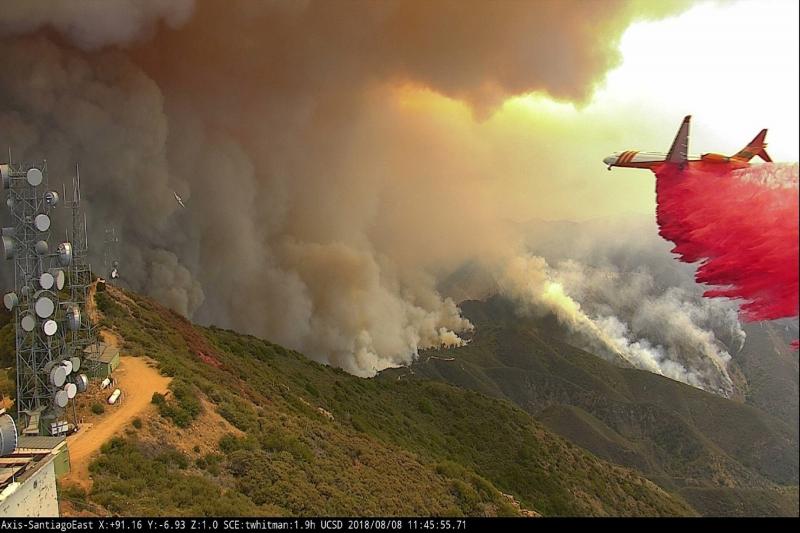
ALERTWildfire uses a network of Axis PTZ cameras to track wildfire outbreaks,
pinpoint ignition sites, monitor conflagrations, and inform incident command
decisions on deploying resources and initiating evacuations.
Mission
With wildfires spreading across western United States at increasing intensity and speed, ALERTWildfire wanted to deploy high quality camera technology in forested areas to help firefighters and the public spot fire ignitions before they burst into full-fledged conflagrations. Because the cameras would be installed in remote locations, they needed to be rugged enough to withstand the elements, including seismic activity. They also had to deliver crystal-clear images under a variety of lighting conditions and have a zoom capability to confirm fires that might be 70 miles or more away.
Solution
ALERTWildfire turned to Professional Telecommunications Services (PTS) of California, an Axis partner, for suggestions. After testing nearly 200 competitive products, PTS recommended the high-performance AXIS Q60 Network Cameras. These cameras proved that they could deliver superior video quality even in lowlight and could withstand the arctic temperatures on mountaintops. To date, ALERTWildfire has installed more than 800 Axis cameras on fire towers, cell towers, and private communications infrastructures across six states to help firefighters and the public monitor forests for hot spots and to provide ongoing situational awareness.
Result
During the past eight fire seasons, the Axis cameras have assisted in combatting more than 2000 fires saving countless lives and property along the way. When a flareup is spotted, first responders can remotely control the cameras to triangulate its location. Early detection in the incipient phase of the fire has led to more rapid dispatch of emergency services and in dozens of cases prevented those fires from flaming out of control. Because the ALERTWildfire website posts live streams from the Axis cameras, the public can also monitor the situation to determine if they’re in the fire’s path and when they might need to evacuate.
Automating fire spotting
The rise in massive wildfires, especially in the western United States, has had a devastating impact on human lives and property, and caused enormous ecological damage to local habitats. Recognizing that early detection gives firefighters a greater chance of containment, young students from Meadow Vista, California approached the Nevada Seismological Laboratory at the University of Nevada, Reno to help them design a social media empowered technology solution to improve fire spotting.
Their award-winning AlertTahoe pilot program, which focused on the region surrounding Lake Tahoe, called for seeding the forest with pan-tilt-zoom (PTZ) video cameras connected to a microwave network to watch for ignition points and alert local fire stations. The students also included an innovative social media component to enable the public to view the live streaming video and serve as additional forest guards.
The 4-year-long pilot led to the launch of ALERTWildfire, a project initially headed by a consortium of three universities (University of Nevada, Reno, University of California San Diego, and University of Oregon). Since then other universities and partners have joined the project, including many local municipalities, state and federal agencies, public utilities, wireless internet services providers, local fire departments, and ski resorts, as well as a cadre of citizen volunteers.


Tinggalkan Balasan